
How satellite technology is fighting COVID-19

Telemedicine has been used by the space industry since the start of human spaceflight to understand the impact of weightlessness on astronauts.
NASA first started experimenting with the satellite provision of healthcare back in 1966, when the ATS-1 spacecraft was used to provide patient care to rural neighbourhoods in Alaska. This was motivated by the lack of local medical infrastructure, high rates of tuberculosis within the indigenous Native American community and the need to demonstrate the value of satellite applications to state and federal agencies.

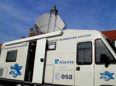
Since ATS-1, satellite-based telemedicine has been successfully used in countries such as Australia, Albania, Canada, India, Italy, Romania, Russia and Scotland. In 1996, the ESA provided a satellite communication system to link Italian doctors with a field hospital in Sarajevo, Bosnia, enabling teleconsultations for both civilian and military patients.
In 2001, ISRO established a dedicated satellite-telemedicine network throughout India offering cardiology, diabetology, mammography, ophthalmology, radiology, X-ray and other healthcare services using its GSAT-3, GSAT-12 and INSAT-3C spacecraft. 75% of Indian doctors practise in urban centres whereas the majority of the population live in remote villages. It has been calculated that patients saved 81% of the cost which they would have otherwise spent if they had to travel to the nearest city for similar treatment. Following the tsunami in 2004, post-relief, mobile satellite-telemedicine stations were set up on the Andaman and Nicobar Islands.
In 2013, Hughes Network Systems signed a deal to use its Spaceway 3 satellite to provide broadband communication for telemedicine from three trucks and a boat, offering vital healthcare services to migrant farm workers and rural communities in the US states of Maine, New Hampshire and Vermont.
Today, satellite technology is increasingly being used to improve health care by providing high-bandwidth, multimedia patient information to aid shared clinical decision-making and early diagnosis. Remote visual and telephone consultations help to alleviate busy surgeries and minimise the spread of germs.
Today, some paramedics carry equipment which uses satellite communication to stream live vital signs such as ECG, temperature, respiration rate and blood pressure to doctors who are due to take over their treatment. The link allows two-way, real-time consultation, allowing the ambulance team to take rapid clinical and transport decisions. It also enables seamless patient care as the casualty is transferred from the paramedics to the hospital.
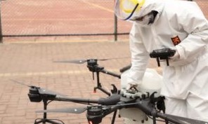
Due to the contagious nature of COVID-19, the use of satellite communication allows quarantined diagnosis without increasing the amount of face-to-face contact between patients and healthcare providers, a major step in reducing the risk of spreading the disease. Other technologies such as using robots to disinfect hospitals and autonomous drones to deliver medical supplies and meals, both of which are being assisted by high-accuracy satellite navigation, are preventing cross-infection allowing countries to contain coronavirus. AI is being used to process the large amounts of data which have been collected to expedite the development of a vaccine, with the large internet giants contributing their computing resources and expertise.
Imagery from Earth observation satellites is currently being used to create population density maps, which are being combined with census data to identify demographics of vulnerable population groups such as the young or elderly. In China, the HaiGe Smart Epidemic Prevention Management Platform was used to plan the routes of commuters to avoid highly contagious COVID-19 areas. By connecting the databases of infected persons and local geographic information, the HaiGe software is capable of displaying the real-time cartography of disease locations and identifying hotspots with the use of a trajectory-tracking algorithm. After comparing the location of the source of an infection with the common route of employees’ daily commute, and analysing the density of people and vehicles at different times, the system replans a safer journey to work.
Satellite navigation is being used to monitor the movements of carriers of COVID-19 who have not been hospitalised, as well as geo-referencing patient data to be shared between doctors and patients. It is also being used to validate access to school lessons based on the location of pupils and the time when the learning occurred. Geolocation is being used by some countries to inform people if they have been in close contact with a carrier and to quarantine themselves.
Satellite communication is helping families and friends maintain communication using social media applications during self-isolation. The positive impact this is having on our general wellbeing cannot be underestimated, particularly for those who live alone or the elderly. Increasingly, many of you now use space-based internet to connect online and work from home during periods of self-isolation.
Space-based assets comprising satellite communication, navigation, Earth observation, internet and mobile telemedicine stations, combined with autonomous technologies and geographic information systems, are playing are a vital role in delivering health care, preventing cross-infection between carriers and doctors and containing the highly contagious coronavirus. Consequently, parts of China are returning to normality with lockdowns being lifted and a relaxation in social distancing.
I’d like to add my thanks and sincere gratitude to our wonderful healthcare professionals who are in the frontline of the fight to keep us all safe. I also wish every one of my Australian readers good health and hope my articles on space electronics and satellite applications are keeping you informed during this period of self-isolation!
Making regular GPS ultra-precise
The GPS system can be slowed by the 'urban canyons' created by tall skyscrapers in big...
The evolution of GPS
Australia and New Zealand's positioning system, SouthPAN, will soon provide a wide range of...
Why secure GPS receivers are crucial for GNSS/INS systems
Resilient GPS/GNSS receivers protect INS systems from jamming and spoofing.


